Log in
All resources
Create a design
5,876 Free Artworks of Image Map
maps from the earth and its inhabitants, vol. iv
arnold's geographical handbook (1899)
maps from the earth and its inhabitants, vol. xviii
maps from the earth and its inhabitants, vol. xiv
maps from the earth and its inhabitants, vol. xiii
maps from the earth and its inhabitants, vol. viii
maps from the earth and its inhabitants, vol. xv
maps from the earth and its inhabitants, vol. xvi
1870s maps of london
temperature maps
maps from the earth and its inhabitants, vol. viii
maps of the mekong
maps from the earth and its inhabitants, vol. iv
maps of snowdonia
maps from the earth and its inhabitants, vol. xv
hydrological maps of the united states
19th-century maps of namibia
maps of walvis bay
maps from the earth and its inhabitants, vol. xvi
maps of the history of mexico
maps from the earth and its inhabitants, vol. iv
old maps of hastings, england
maps from the earth and its inhabitants, vol. xv
maps of the history of alaska
19th-century maps of sierra leone
maps of rivers of sierra leone
maps from the earth and its inhabitants, vol. viii
temperature maps
maps from the earth and its inhabitants, vol. iv
1870s maps of london
maps from the earth and its inhabitants, vol. xii
maps of ocean currents
maps from the earth and its inhabitants, vol. x
maps of lake victoria
maps from the earth and its inhabitants, vol. iv
old maps of the isle of arran
maps from the earth and its inhabitants, vol. xviii
1870s maps of peru
maps from the earth and its inhabitants, vol. iv
19th-century maps of cornwall
maps from the earth and its inhabitants, vol. vii
1870s maps of japan
maps from the earth and its inhabitants, vol. iv
maps of balmoral castle
maps from the earth and its inhabitants, vol. x
1870s maps of egypt
maps from the earth and its inhabitants, vol. iv
old maps of bristol
maps from the earth and its inhabitants, vol. xiv
1870s maps of australia
maps from the earth and its inhabitants, vol. xviii
maps of the indigenous peoples of south america
maps from the earth and its inhabitants, vol. xiv
old maps of sydney
maps from the earth and its inhabitants, vol. iv
old maps of the firth of forth
maps from the earth and its inhabitants, vol. iv
bathymetric maps of the north sea
maps from the earth and its inhabitants, vol. v
maps of spitsbergen
maps from the earth and its inhabitants, vol. xv
temperature maps of north america
maps from the earth and its inhabitants, vol. iv
old maps of sunderland
maps from the earth and its inhabitants, vol. iv
maps of the humber estuary
maps from the earth and its inhabitants, vol. viii
temperature maps
maps from the earth and its inhabitants, vol. iii
1870s maps of switzerland
maps from the earth and its inhabitants, vol. xiii
maps indicating exploration
maps from the earth and its inhabitants, vol. iv
old maps of windsor
maps from the earth and its inhabitants, vol. vii
1870s maps of china
maps from the earth and its inhabitants, vol. iv
maps of tides
maps of borders of ecuador
1870s maps of ecuador
maps from the earth and its inhabitants, vol. iv
old maps of dover, kent
maps from the earth and its inhabitants, vol. iv
1870s maps of london
maps from the earth and its inhabitants, vol. xiii
1870s maps of africa
maps from the earth and its inhabitants, vol. xiii
1878 maps of africa
maps from the earth and its inhabitants, vol. xviii
maps of weather and climate of south america
maps from the earth and its inhabitants, vol. iv
old maps of leeds
maps from the earth and its inhabitants, vol. xi
1870s maps of algeria
maps from the earth and its inhabitants, vol. xviii
old maps of valparaíso
maps from the earth and its inhabitants, vol. iv
old maps of exeter
maps from the earth and its inhabitants, vol. xiv
1870s maps of indonesia
maps from the earth and its inhabitants, vol. iv
maps of rochester, kent
maps from the earth and its inhabitants, vol. viii
maps of the mekong
maps from the earth and its inhabitants, vol. xvi
old maps of central america
maps from the earth and its inhabitants, vol. iv
1870s maps of scotland
maps from the earth and its inhabitants, vol. iv
19th-century maps of the english channel
maps from the earth and its inhabitants, vol. iv
public transport maps of london
maps from the earth and its inhabitants, vol. iv
maps of guildford
maps from the earth and its inhabitants, vol. xvi
19th-century maps of mexico city
maps from the earth and its inhabitants, vol. xv
1870s maps of quebec
maps from the earth and its inhabitants, vol. xvi
maps of central america
maps from the earth and its inhabitants, vol. iv
old maps of swansea
maps from the earth and its inhabitants, vol. iv
maps of falmouth, cornwall
maps from the earth and its inhabitants, vol. iv
1870s maps of scotland
maps from the earth and its inhabitants, vol. iv
old maps of the river thames
maps from the earth and its inhabitants, vol. iv
old maps of leeds
maps from the earth and its inhabitants, vol. xviii
1870s maps of peru
maps of ardabil province
maps of sabalan
maps from the earth and its inhabitants, vol. iv
drainage basin maps of the united kingdom
maps from the earth and its inhabitants, vol. xiv
old maps of sydney
maps from the earth and its inhabitants, vol. iv
precipitation maps
maps from the earth and its inhabitants, vol. iv
1870s maps of wales
maps of natal colony
maps of zululand
curt teich postcard archives
map postcards
maps of hrodna by braun & hogenberg
historical images of hrodna
description de l'universe
prints of ships
old maps of the eastern hemisphere
1680s maps of the world
old and new london, illustrated (1873) by walter thornbury and edward walford - bl 1887 copy
maps from the mechanical curator collection
merian helvetiae, rhaetiae et valesiae
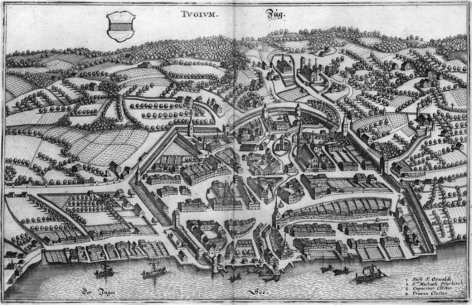
historical images of zug
maps of asilah by braun & hogenberg
history of asilah
corsica in the 20th century
guido colucci
den danske hærs historie til nutiden og den norske hærs historie indtil 1814
maps of battles of sweden
maps in the library of congress
1744 maps
arnold's geographical handbook (1899)
road maps of the united kingdom
arnold's geographical handbook (1899)
1890s maps of central america
arnold's geographical handbook (1899)
old maps of the amazon river
1890s maps of central america
1890s maps of the caribbean
arnold's geographical handbook (1899)
1899 maps of the united states
geological maps of pennsylvania
1885 maps of pennsylvania
19th-century maps of the british isles
arnold's geographical handbook (1899)
old southwark and its people (1878)
16th-century maps of london
maps in the stadsarchief amsterdam
daniël veelwaard (i)
maps from the earth and its inhabitants, vol. iii
mining in austria
tian shan
alps
maps from the earth and its inhabitants, vol. xviii
colonialism
1590s maps of the world
cornelis de jode
moluccas in the 17th century
asia noviter delineata
maps from the earth and its inhabitants, vol. iv
brentford, england
history of samarkand
maps of samarkand
historical images of rome by william henry goodyear
mannerism
the family of frederick, prince of wales (george knapton - windsor castle)
prince edward (great britain) in 1751
arnold's geographical handbook (1899)
1890s maps of new zealand
arnold's geographical handbook (1899)
maps of the panama canal
west-indische compagnie
image restoration
maps in the library of congress
cartes et plans de l'amerique
maps and topographical views by joris hoefnagel
historical images of louny
901 - 1000 of 5,876
Next page
/ 59